Last Saturday I spent the day at Cumberland Island with some friends. It was a fun day, and a good opportunity to explore the main points of interest on the island. I had been wanting to visit Cumberland Island since last year, when I had to cancel a planned week long trip because it was about to happen at the same time I got sick and ended up spending extended time in the hospital.
Transportation to the island is by ferry, and it leaves at 9am from the dock in St. Marys. There are 2 return trips at 2:45pm and 4:45pm on Saturdays. On weekdays there is only the 4:45 return. The trip is about 45 minutes up the St. Marys River.
[click any photo to enlarge]
 |
| #M4_02746 - The Beach at Cumberland Island |
The island is an interesting place to see. There are lots of old oak trees and most are covered with Spanish moss which remind me of moss covered trees scattered around the school I attended in Jacksonville as a child.
 |
| M4_02733 - Oak Tree in front of Carnegie Mansion |
 |
| M4_02744 - Salt Marsh at low tide |
Some items of interest in the island are the 24,000 square foot Carnegie Mansion, and the ruins of Dungeness castle, which was a 59 room Scottish castle built by Thomas Carnegie, although he died before it was completed. Dungeness was named by Thomas' wife, Lucy, after another building on the island that had burned down some years earlier. Dungeness was also destroyed by fire in 1959 and was vacant at the time. Also on the island is the small chapel where John F. Kennedy, Jr. was married.
There are approximately 160 wild horses roaming freely on the island, and we saw lots of them during our day there, including several ponies. The horses were the main attraction that I hoped to be able to photograph.
 |
| M4_02645 - Wild Horses |
 |
| M4_02626 - Wild Horses |
 |
| M4_02544 - Wild Horses |
 |
| M4_02606 - Pony |
 |
| M4_02607 - Pony with Mother |
 |
| M4_02826 - White Pony |
When we arrived at the Dungeness ruins, we walked behind the structure and saw a group of about a six or eight horses, including this white pony that was with his mother, nursing at the time. I tried to get a few close up photos of him because he looked really cute.
We walked around completely around the Dungeness ruins and I took some photos from different angles. I am only posting two of them below; one from the front and one from the back. We did not approach the horses very closely and they didn't seem to mind us being there.
 |
| M4_02780 - Ruins of Dungeness Castle (front) |
 |
| M4_02842 - Dungeness Ruins (back) |
Shown below is the small chapel (First African Baptist Church) where John F. Kennedy Jr. was married. It was built in 1937 to replace an earlier structure that was built in 1893.
 |
| M4_02769 - Chapel (JFK Jr was married here) |
 |
| M4_02762 - Inside the Chapel |
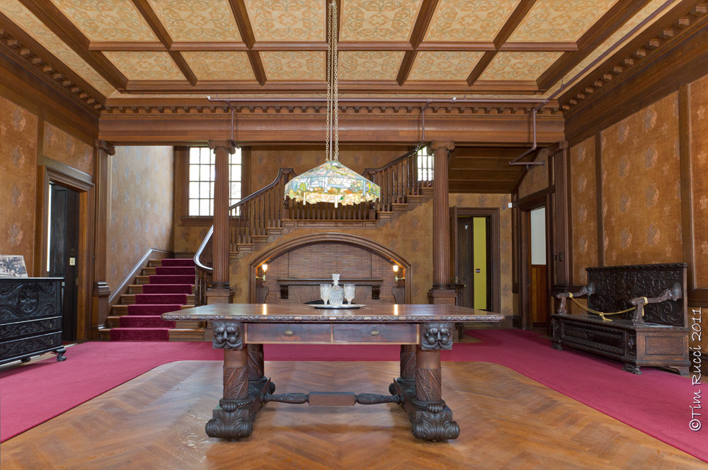
We were also able to take a tour of the Carnegie Mansion. It is being restored by the National Park Service and most of the first and second floor is accessible to visitors. The images below show some exterior views and some of the spaces inside that I felt were interesting. An air conditioning system has been added during the restoration to allow visitors to tour the building in comfort.
 |
| M4_02669 - Carnegie Mansion |
 |
| M4_02687 - Inside the Carnegie Mansion |
 |
| M4_02688 - Inside the Carnegie Mansion |
 |
| M4_02693 - Inside the Carnegie Mansion |
 |
| M4_02712 - Inside the Carnegie Mansion |
 |
| M4_02722 - Inside the Carnegie Mansion |
Below is a photo of our gang having lunch under the oak trees next to the Carnegie Mansion. If you plan to visit Cumberland Island, you'll need to pack yourself a lunch and bring a water bottle or two to get you through the day.
There is no food service on the island unless you are staying at the Greyfield Inn. There are no stores or restaurants, and you must pack out your trash and take it back out with you. Likewise, there are no paved roads or trails, and no way to bring a vehicle onto the island. Virtually all travel is on foot or by bicycle (rentals available) unless you take a van tour of the island. There are several camping sites on the island but only one has running water and bathroom facilities with cold showers.
We took an all day van tour that got us to the points of interest that I've shown in the photos. The dirt roads are very rough and full of holes, and we all felt like bobble head dolls by the end of the day. But it was a fun time and very interesting. Reservations are recommended for both the ferry and for island tours. The National Park Service limits the number of visitors on the island to no more than 300 at a time.
 |
| M4_02736 - Lunch time |